Piriapolis

Piriápolis

category Uruguay, South America
UruguaySouth America

Piriápolis is a beautiful coastal resort in the eastern part of Uruguay, known for its particularly relaxed atmosphere and stunning natural landscapes. Located about 100 km from Montevideo and 30 km from Punta del Este, it is gaining popularity as an ideal holiday destination for both Uruguayan and local tourists. Here you will find amazing beaches, beautiful mountains, historic buildings and recreational activities. I will explain in detail the charm of Piriápolis.


Historical background of Piriápolis

The origins of Piriápolis date back to the end of the 19th century. In 1889, a Uruguayan entrepreneur named Francisco Piria developed Piriápolis as a resort area. Francisco Piria is known as a pioneer of tourism in Uruguay, and his vision shaped Piriápolis as a luxury resort in Uruguay. Piria built luxurious villas, hotels and public facilities in this area where the coastline and mountains blend beautifully, enhancing the appeal of the resort.

Piriápolis has since become a popular attraction for both domestic and foreign tourists, especially during the summer season. As the resort developed, Piriápolis became known as the "Carnival of Uruguay" and became a favorite of the country's wealthy.


Natural Landscapes & Activities

The biggest attraction of Piriápolis is its Natural beauty Are. The coastline, mountains, forests and vast sandy beaches blend together to provide visitors with the ideal setting for relaxation and adventure. The area around Piriápolis is dotted with spots where you can enjoy a variety of nature activities.


1. Beach

Piriápolis has several beautiful beaches. One of the most popular is Playa Piriápolis. This beach is characterized by gentle waves and long sandy beaches, perfect for swimming and sunbathing. There are also walking and bike paths along the coast, making it an ideal place for those who enjoy strolling. There are also many cafes and restaurants around the beach, where you can enjoy fresh local seafood.

2. Cerro del Toro

Piriapolis is Mountainous Regions We are also blessed. One of the highest mountains is the Cerro del Toro. It is known as a scenic spot overlooking the town of Piriápolis. You can climb this mountain, and from the top you can enjoy a panoramic view of the beaches of Piriápolis and the surrounding natural scenery. For travelers who enjoy mountaineering, this area is perfect for hiking and nature viewing.

3. Piriápolis Waterpark

Piriápolis also has a wealth of leisure activities for families. Piriápolis Water Park is a great spot to have fun with the kids. This water park features a pool, waterslides, spa, and more, making it a fun place to refresh with a refreshing splash of cold water, especially for tourists visiting during the hot summer months.


Historical Buildings and Attractions

Piriápolis is not only home to beautiful natural landscapes, but also to a large number of historic buildings and landmarks. These buildings tell the story of the resort's history and add to the charm of the town.

1. Casino Piriápolis

Piriapolis Casino is a historic casino built at the beginning of the 20th century and is a symbol of the town. The casino is a symbol of the glamorous era of the resort, with luxurious and artistic interiors. It is still open today, and tourists can enjoy games inside the casino and relax in the surrounding restaurants and cafes.

2. Piriápolis Lighthouse (Faro de Piriápolis)

It is one of the symbols of Piriápolis Piriapolis Lighthouse overlooks the beautiful sea in the city. This lighthouse was built in 1910 and is still in use, making it a worthwhile spot for tourists. You can climb to the lighthouse, and from the top you can enjoy sweeping views of the Piriápolis coastline and the surrounding mountains.

3. Monuments and squares of Piriápolis

In the center of the town is dedicated to Francisco Pilia, the founder of Piriápolis Monuments and is a place to honor his achievements. The area around the squares and monuments is a bustling gathering place for tourists and locals, making it a great area for a break or a stroll.


Culture & Events in Piriápolis

Piriápolis is also known for hosting a variety of cultural events and festivals. Especially Summer Season Music festivals and art festivals are held in the city, and many tourists visit. These events feature traditional Uruguayan music and dances, giving tourists a deep understanding of Uruguayan culture.

Piriápolis is also a thriving area for ecotourism and outdoor activities due to its beautiful natural environment. Cycling, hiking, kayaking, windsurfing and many other recreational activities are available. In particular, nature reserves and national parks are nearby, and tourism activities that take care of the environment are encouraged.


How to get there and where to stay

Access to Piriápolis is easy from Uruguay's major cities. It is about one and a half hours by car from Montevideo and about 30 minutes from Punta del Este, making it easily connected to the surrounding tourist destinations.

Accommodation is also substantial, Luxury from Ecolodge There are a variety of options to suit the needs of travelers. Resort hotels, especially along the coastline, allow you to enjoy spectacular sea views.


summary

Piriapolis is one of Uruguay's most attractive tourist destinations, with a wealth of natural landscapes, historic buildings, activities and cultural events. While you can enjoy a relaxing beach life, you can also enjoy outdoor activities and historical attractions, making for an unforgettable experience for visitors. Piriápolis, where you can enjoy Uruguay's nature and culture, has plenty of charm as a tourist destination.

basic information

Opening hoursClosed daysFee
Always opennonefree

map

Other spots

  • La Santísima Trinidad de Paraná

    ParaguaySouth America

    La Santísima Trinidad de Paraná is one of the 17th-century Jesuit mission ruins in Paraguay and is an extremely important site as a historical and cultural heritage of South America. Registered as a UNESCO World Cultural Heritage Site in 1993, it attracts many tourists and researchers as a symbol of the fusion between Jesuit missionary work and indigenous cultures. Here, we will explain in detail its historical background, the structure of the ruins, cultural significance, and tourist appeal.


    1. Historical Background and Construction History

    In the early 17th century, the Catholic Church in Europe intensified its missionary activities in the New World, with the Jesuits in particular promoting Christian education among indigenous peoples throughout South America. In the region spanning southern Paraguay, Argentina, and near the border with Brazil, the indigenous Guaraní people lived, and the Jesuits established several missions (reductions) aiming for coexistence with them.

    La Santísima Trinidad de Paraná Construction began in 1712, and at its peak, it is said that about 3,000 indigenous people lived there. The mission was organized around communal activities such as agriculture, livestock farming, and handicrafts, providing not only religious education but also social self-governance. Following Jesuit design principles, the church was placed at the center, surrounded by schools, residences, plazas, and workshops.


    2. Structure and Architectural Features of the Ruins

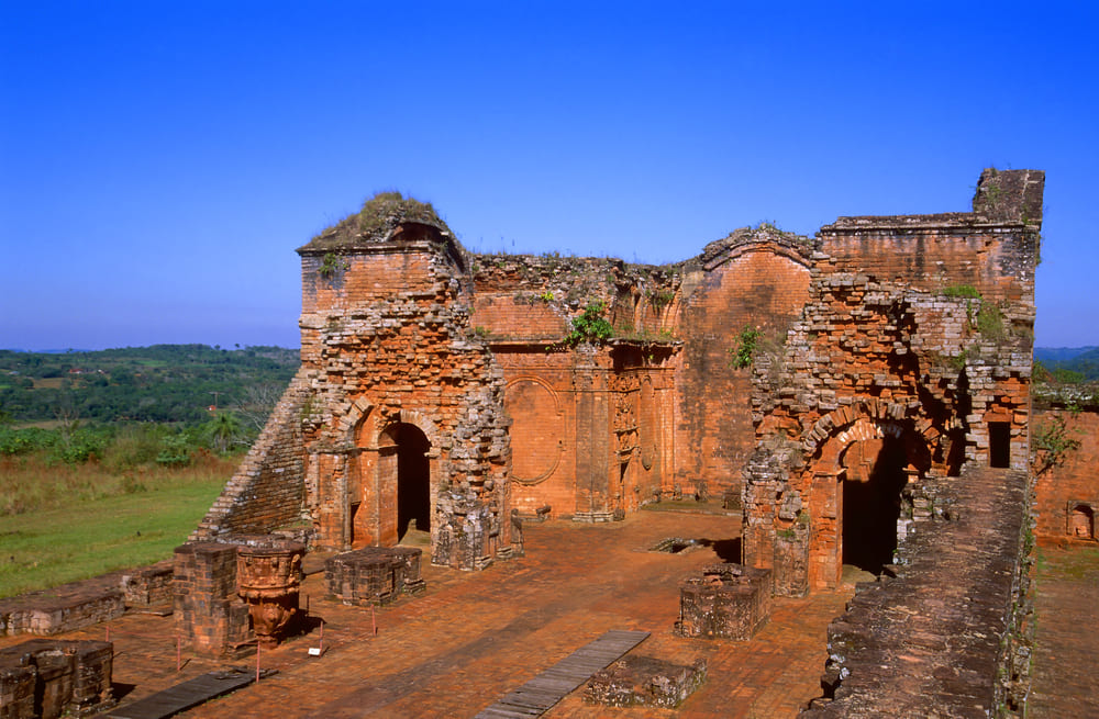
    The ruins of La Santísima Trinidad still retain parts of their magnificent stone structures, and their scale and excellent state of preservation are among the finest of the Jesuit sites in South America.

    ■ Church

    The cathedral at the center of the mission was built in a magnificent Baroque style, with a tall stone façade adorned with carvings. Inside the church, the altar and pulpit are beautifully preserved, indicating that it was the focal point for religious ceremonies.

    ■ Housing and public facilities

    Surrounding the church were the residences, schools, and workshops of the indigenous people, creating a space where daily life and religious activities were integrated. The dwellings were a mix of stone and wood construction, and archaeological excavations have revealed traces of the residents’ lifestyles and handicrafts.

    ■ Plaza

    The central plaza served as a venue for community gatherings and festivals, and its vast space has been preserved to this day. One can imagine that many scenes of daily life once unfolded here.


    3. Cultural Significance and Historical Role

    La Santísima Trinidad de Paraná was not only a center for Jesuit missionary work, but also, and most importantly, an experimental ground for a "symbiotic society" where indigenous and European cultures merged. The intersection of Jesuit educational principles and Guaraní traditions fostered the development of a unique social structure, as well as the preservation of distinctive arts and language.

    Moreover, these missions served as important social and economic centers within the colonial policies of the time, contributing to the protection of indigenous peoples, the management of labor, and the stabilization of the region. In the 19th century, the dissolution of the Jesuits and ensuing political turmoil led to the decline of the missions, which now remain as ruins that bear witness to their history.


    4. Tourist Attractions and Local Experiences

    Today, La Santísima Trinidad de Paraná has been developed as one of Paraguay's premier tourist destinations, attracting many visitors seeking to explore its history and deepen their understanding of its culture.

    ■ Ruins tour

    Guided tours offer detailed explanations of the structure of the ruins, their historical background, and the relationship between the Jesuits and the Guaraní people. Visitors can also view intricate sculptures and displays of everyday items, allowing them to vividly imagine life as it was in those times.

    ■ Cultural Events

    The region also hosts traditional music, dance, and festivals, giving visitors the opportunity to experience aspects of indigenous culture. There are markets for handicrafts as well, where locally made textiles and woodwork by artisans can be purchased.

    ■ Natural environment

    The area around the Paraná River, where the mission is located, is rich in natural beauty, offering opportunities for birdwatching and nature walks. The harmonious blend of historical ruins and lush nature creates a relaxing environment that is part of its unique appeal.


    5. Access and Surrounding Information

    La Santísima Trinidad is located about four hours by car from Paraguay's capital city, Asunción. Other Jesuit mission ruins, such as San José de Candias, are scattered nearby, making the area a popular route for exploring historical sites.

    Although simple, there are accommodations and restaurants in the surrounding area, allowing visitors to enjoy local cuisine and hospitality. When visiting, it is important to respect the local culture and act with consideration for the preservation of the ruins.


    summary

    La Santísima Trinidad de Paraná is a historic site where the Jesuits' religious mission intersected with the culture of the indigenous Guaraní people, making it an essential place for understanding the colonial era of South America. Its remarkable state of preservation and magnificent stone architecture deeply move visitors, offering a profound sense of the layered drama woven by culture and history.

    Visiting this site is more than just sightseeing; a valuable opportunity to learn about past cultural exchange and coexistence, and to gain lessons for the future. it will surely become a meaningful experience. When visiting Paraguay, be sure to explore this historical heritage and experience a glimpse of South America's diverse cultures.

    Learn more

  • Santa Lucia Hill

    ChileSouth America

    Cerro Santa Lucía is a small hill located in the heart of Santiago, the capital of Chile. It serves as a relaxing retreat for both locals and tourists, and is also an important tourist attraction symbolizing Chilean history. Despite being surrounded by the hustle and bustle of the city, this hill offers a unique space where visitors can enjoy nature, culture, and breathtaking views, making it one of the must-see destinations in the capital. In the following, we will provide a detailed introduction to Cerro Santa Lucía, including its history, architectural highlights, natural features, and access information, in approximately 2,000 characters.


    1. Historical Background

    Cerro Santa Lucía is a small hill with an elevation of about 70 meters, and was originally called "Huelén" by the indigenous Mapuche people. was what it was called. It was here that the Spanish conquistador Pedro de Valdivia arrived in 1540. From the top of this hill, he surveyed the surrounding landscape, and the following year, he founded what is now the city of Santiago at the foot of the hill. In other words, this hill It is an extremely important historical site that can be considered the birthplace of the city of Santiago.

    In 1872, under the urban redevelopment plan led by then-mayor Benjamín Vicuña Mackenna, the hill underwent major improvements. What was once a military outpost and rocky terrain was transformed into a beautiful park featuring European-style gardens, fountains, observation decks, and statues. Many of the structures seen on Cerro Santa Lucía today were developed during this period.


    2. Sightseeing and Architectural Beauty

    Although Cerro Santa Lucía is not very high, from the top of the hill the cityscape of Santiago and the Andes Mountains it is a popular spot for its panoramic views. The entire hill is like a maze, with stairs, walking paths, terraces, gates, and statues, making it a delight to explore.

    ■ Neptune Fountain (Fuente de Neptuno)

    One of the most famous landmarks at the foot of the hill is this fountain. Its magnificent Baroque architecture and the striking golden statue of Neptune make it especially impressive. It is a very popular photo spot, and many tourists stop here to take pictures.

    ■ Castillo Hidalgo

    Near the top of the hill stands a structure built in 1816, Hidalgo Castle known as Castillo Hidalgo. Originally a fortress from the Spanish colonial era, it is now used as an event venue and cultural facility. The contrast between its solid stone exterior and the surrounding greenery is truly beautiful.

    ■ Observation Deck (Mirador)

    From the observation deck at the very top of the hill, you can enjoy a 360-degree panoramic view of Santiago on clear days, with the majestic Andes Mountains stretching out in the distance. Morning and evening are especially recommended times to visit, as the scenery is particularly photogenic.


    3. The charm of nature and plants

    The entire hill is covered with many Plants and flowers are carefully maintained and planted, offering different scenery with each season. In spring, in particular, colorful flowers bloom in abundance, making it the perfect place to relax in nature.

    The harmony between the stone structures and the greenery on the hill creates a landscape reminiscent of a European castle park. Whether you sit on a bench to read a book or simply take a quiet stroll, the atmosphere is truly refreshing.


    4. A Place for Locals and Tourists to Connect

    Cerro Santa Lucía is not just a tourist attraction; it is also a place of relaxation for local residents. People of all ages, from students and couples to the elderly, visit to enjoy walks, reading, lunch, and spending time as they please.

    Also, on holidays art markets and craft fairs are sometimes held here, providing opportunities to experience Chilean culture and local art. Occasionally, there are live music performances and dance shows, making the entire hill a hub of cultural activity.


    5. Access and Admission Information

    Santa Lucía Hill is located in the center of Santiago, making it extremely easy to access.

    • subway Just a short walk from **Santa Lucía Station** on Santiago Metro Line 1.

    • Admission fee :Admission is free (There may be an admission fee during special events.)

    • Opening hours : Usually 9:00 AM to 7:00 PM until (subject to seasonal changes).

    Since there are many stairs to climb the hill, comfortable walking shoes are recommended. Also, on sunny days, don't forget to bring a hat and water.


    summary

    Santa Lucia Hill is a valuable tourist spot where you can enjoy rich nature, artistic architecture, historical background, and beautiful scenery all at once, right in the heart of Santiago. Visiting here allows you to experience firsthand that Chile's capital is not just a modern city, but one deeply rooted in history and culture.

    This hill is a must-visit when sightseeing in Santiago. If you have time, enjoy the morning tranquility, the lively atmosphere during the day, and the romantic scenery at sunset. A place worth visiting at different times of the day Here, you can fully experience the charm of Chile as you relax both body and mind on this hill.

    Learn more

  • Marble Cathedral

    ChileSouth America

    The Marble Caves are a mesmerizing natural work of art located in Patagonia, southern Chile, and are officially known as the 'Catedral de Mármol' (Cathedral of Marble). These marble caves were carved out over thousands of years by water and wind, and are characterized by the beautiful patterns created by the interplay of the lake's blue and the marble's white. It is one of Chile's most secluded wonders and a dream destination for nature lovers and photographers from around the world.

    Below, we will introduce the charm of the Marble Caves in detail, including their formation, location, highlights, and how to access them.


    1. What are the Marble Caves?

    The Marble Caves are a group of marble caves located on the shores of Lake General Carrera (Lago General Carrera) in southern Chile. This lake spans both Chile and Argentina, where it is known as 'Lake Buenos Aires' on the Argentine side. The Marble Caves are situated on the Chilean side, along the Carretera Austral. a small town along the They are located near Puerto Río Tranquilo.

    This cave system consists of three main areas: the Marble Chapel (Capilla de Mármol), the Marble Cathedral (Catedral de Mármol), and the Marble Cave (Cueva de Mármol), each with its own unique shapes and beauty.


    2. Formation and Natural Wonders

    The Marble Caves were formed approximately 60 million years ago when marble bedrock was gradually eroded by water over thousands of years, resulting in the complex and beautiful shapes seen today. Meltwater from glaciers, rich in calcium, slowly wore away the marble, creating smooth curves and formations resembling ceilings and pillars.

    The color of the water changes dramatically depending on the season, weather, and lighting. On sunny days, it shines emerald green or cobalt blue, while on cloudy days or at dusk, it turns a deeper blue or silvery hue. This Contrast of light and stone creates a majestic and beautiful atmosphere, just like a natural cathedral.


    3. Tourist attractions

    Access to Marble Caves is primarily by

    Access to the Marble Caves is generally For those seeking a more active experience, by boat. Guided tours departing from Puerto Río Tranquilo are common and take about 1 to 2 hours. As you glide across the lake, you can closely observe the patterns on the rock surfaces and the clarity of the water.

    ■ Kayaking experience

    For those seeking a more active experience, Kayak Tour It is very popular. Entering the cave on your own and being enveloped by the marble space above the tranquil water is an indescribable experience. Viewing the cave from just above the water’s surface creates a fantastical atmosphere, as if you have wandered into another world.

    ■ Seasonal changes

    Depending on the season you visit, the lake’s water level and the way light enters change, resulting in different patterns and colors. The best time to visit is during the dry season from spring to summer (November to March), when the weather is mostly clear and the water is transparent and calm.


    4. How to Get There and Travel Tips

    While the Marble Caves are an exceptionally beautiful place, Not easily accessible it is essential to plan your trip carefully.

    ■ Route from Santiago

    • Air : From the capital Santiago, it takes about 2.5 hours by plane to Balmaceda, a town in southern Chile.

    • Land route : From Balmaceda, drive or take a bus along the Carretera Austral for about 5 to 6 hours to reach Puerto Río Tranquilo.

    This route is scenic, with beautiful Patagonian landscapes including glaciers, lakes, and mountains along the way. Some sections of the road are unpaved, four-wheel drive vehicle is recommended.


    5. Tourism Value and Environmental Protection

    For visitors, the Marble Caves are A once-in-a-lifetime view a truly special place, but its natural environment is extremely delicate. With the increase in tourists, there are concerns about water pollution from motorboats and damage to the rock surfaces.

    Therefore, the Chilean government and local organizations Sustainable Tourism are strengthening measures such as licensing tour companies and training guides to ensure sustainable tourism. Visitors are also expected to follow good manners to protect the natural environment, such as not touching, not littering, and observing quietly.


    summary

    The Marble Caves are a miraculous creation of Chilean nature. The blue, shimmering lake and the smooth, sculpted marble caves are truly Visiting this place holds more meaning than just tourism. It is one of a kind. Despite the challenging access, many tourists visit each year in search of their mysterious beauty.

    Visiting this place means more than just sightseeing. It is An experience that lets you witness the grandeur of nature and the passage of time an opportunity to quietly reflect on yourself in a place far removed from civilization.

    If you have the chance to travel to Chile, the Marble Caves are a hidden gem you should definitely visit. Their beauty cannot be fully captured in photos or videos, and can only be truly appreciated by seeing and feeling them for yourself. There is emotion there.

    Learn more

  • Plaza de Armas

    ChileSouth America

    Plaza de Armas is a square located at the historical heart of Santiago, the capital of Chile, and has played an extremely important role in the country’s political, religious, and cultural development. From the Spanish colonial era to the present day, this square has witnessed the changes in Chilean society, and today it serves both as a place of relaxation for citizens and as a must-see spot for tourists.

    Below, we will provide a detailed explanation of Plaza de Armas—its history, surrounding architecture, cultural significance, and appeal as a tourist destination—in approximately 2,000 characters.


    1. Historical Background

    Plaza de Armas was established in 1541 by Spanish conquistadors Pedro de Valdivia as the central point when the city of Santiago was founded. According to Spanish urban planning laws of the time, it was customary to create a 'Plaza de Armas' (literally, 'Square of Arms') at the center of the town, making it the hub for administration, religion, and military affairs.

    Santiago's Plaza de Armas followed this example, with key institutions such as the Governor's Palace, the Cathedral, and the courthouse built around it, functioning as the political, religious, and commercial center of the city. During the colonial era, it hosted markets, festivals, military parades, and even public executions, truly serving as the "heart of the city."


    2. The Present-Day Plaza de Armas

    Today, Plaza de Armas is a tranquil park with manicured gardens and rows of palm trees, serving as a lively gathering place for both locals and tourists. Fountains, benches, sculptures, and street performers create a space where visitors can enjoy their time in an environment where history and the present intersect.

    In the center Statue of Pedro de Valdivia has been erected, and as the city's founder, he still watches over the square today.


    3. Main Buildings and Highlights Around the Plaza

    The area surrounding Plaza de Armas is home to many important buildings that tell the story of Santiago's history, making it a fascinating destination for sightseeing.

    ■ Santiago Metropolitan Cathedral (Catedral Metropolitana de Santiago)

    Located on the west side of the square, this Catholic church began construction in the 18th century and is known for its magnificent façade, which blends Baroque and Neoclassical styles. Inside, visitors will find beautiful stained glass windows, a gilded altar, and the tombs of successive archbishops, all contributing to a serene atmosphere that leaves a lasting impression.

    ■ Central Post Office (Correo Central)

    Located next to the cathedral, this building stands on the site of the former colonial Governor's Palace and was rebuilt in the 19th century in a grand French architectural style. Today, it serves as a post office and also houses a postal museum.

    ■ National History Museum (Museo Histórico Nacional)

    Located on the north side of the square, this museum covers Chilean history from the independence movement to the present day, making it the perfect place to learn about the country's political, social, and cultural changes. The building itself was once the Spanish Governor's Palace and is of great historical value.

    ■ Plaza de Armas Metro Station (Estación Plaza de Armas)

    Santiago's Metro Line 5 runs through here, making it easily accessible for tourists and serving as a key transportation hub.


    4. A Center for Culture and Events

    Plaza de Armas continues to serve as a hub for local culture. On weekends, local artists, musicians, and performers are active in the square, and paintings, photographs, and handicrafts are frequently sold directly to visitors.

    On holidays such as Independence Day, Christmas, and Easter, the square becomes the stage for parades, religious ceremonies, and illuminations, enveloping the entire city in a festive atmosphere.

    There are also many cafés and restaurants around the square, allowing visitors to relax on the street and then enjoy local cuisine. Traditional Chilean dishes such as "empanada" and "cazuela" are especially popular.


    5. Role as a Tourism Hub

    Plaza de Armas is located at the heart of Santiago's historic district, with many tourist attractions within walking distance. It is recommended to combine your visit with the following sites to create a sightseeing route:

    • Cerro Santa Lucía : A viewpoint offering a panoramic view of the city.

    • La Moneda Palace (Palacio de La Moneda) : The presidential palace of Chile and the center of national administration.

    • Centro Gabriela Mistral (GAM) : A hub for contemporary culture and the arts.

    As a starting point for visiting these attractions, Plaza de Armas serves as the gateway for many travelers.


    summary

    Plaza de Armas is more than just a city square, A crossroads of Chile's history, culture, religion, and politics It stands as an extremely symbolic presence. The weight of its history, stretching back to the Spanish colonial era, coexists with the lively atmosphere of a vibrant public space today, attracting many people as a place where the past and present are harmoniously intertwined.

    If you visit Santiago, taking a walk through this square is the perfect first step to experience Chile's culture and spirit. Plaza de Armas is truly The heart of Santiago the heart of the city, and by feeling its pulse, your journey will become even more profound.

    Learn more

  • Churches of Chiloé

    ChileSouth America

    The Churches of Chiloé are a unique group of wooden churches scattered across the Chiloé Archipelago in southern Chile, South America. They are a precious heritage that showcases an unparalleled architectural style and cultural fusion on a global scale. Due to their beauty and historical significance, they were inscribed as a UNESCO World Heritage Site in 2000. These churches are iconic structures that beautifully harmonize the Spanish Catholic missionary activities since the 16th century, indigenous cultures, and the distinctive natural environment of the region.

    Below, we will introduce the Churches of Chiloé in detail, covering their history, architectural features, cultural significance, and appeal as tourist destinations.


    1. What are the Chiloe Islands?

    The Chiloé Archipelago is a group of islands located in southern Chile, just north of the Patagonia region, with the main island, Isla Grande de Chiloé, at its center and many smaller islands scattered around it. This area, covered in temperate rainforests and characterized by frequent fog and rain throughout the year, has fostered a unique culture and traditions distinct from other regions of Chile.

    The Spanish arrived in this region at the end of the 16th century. While advancing Catholic missionary work, they also came into contact with the indigenous Wiliche people peoples, and together they built a new culture where religion and daily life became intertwined.


    2. Features of the Churches of Chiloé

    Most of the Churches of Chiloé are Entirely wooden structures built using local timber wooden structures, yet they combine durability with beauty. In particular, the following architectural features stand out.

    ■ Skillful use of wood

    The churches were mainly constructed using **alerce (a conifer similar to Alaskan cypress) or and **coigüe (a broadleaf tree native to South America)**, as well as other trees native to Chiloé Island. They were ingeniously designed to withstand the humid climate, and thanks to sophisticated woodworking techniques, many have survived for over a century.

    ■ Fusion of Spanish and Indigenous Cultures

    The architecture of the Churches of Chiloé is influenced by European Baroque and Gothic styles, yet it is also fused with local traditions and techniques. This is known as the 'Chilote Style' (Estilo Chilote), and it is recognized as an exceptionally unique style worldwide.

    3. 16 Churches Registered as UNESCO World Heritage Sites

    Many of the churches are painted in vivid colors, with pastel shades of blue, red, yellow, and more standing out beautifully against the lush green island landscape. This colorful appearance is also one of the elements that captivates visitors.


    3. The Sixteen Churches Registered as UNESCO World Heritage Sites

    Currently, the following 16 churches is:

    1. Achao

    2. Aldachildo

    3. Ichuac

    4. Chonchi

    5. Detif

    6. Quinchao

    7. San Juan

    8. Quinchao

    9. Rilan

    10. San Juan

    11. Chaulinec

    12. Vilupulli

    13. Chaulinec

    14. Colonel (Colo)

    15. Chele

    16. 4. Deep Relationship with Local Communities

    These churches were built between the 17th century and the early 20th century, with many constructed by local carpenters using traditional craftsmanship. Even today, Catholic Mass is held in them, making them deeply rooted in the faith and daily life of the local community.


    4. Deep Connection with the Local Community

    The Churches of Chiloé are not merely religious facilities, Regional cultural center but also serve as important community centers. Many of the islanders' life events—such as weddings, baptisms, harvest festivals, and celebrations of patron saints—have taken place in these churches.

    Furthermore, the maintenance and restoration of the churches are carried out by local residents. Skilled carpenters known as "Maestro Mayor" continue to pass down traditional building techniques to this day. This approach to cultural heritage preservation has also been highly praised by UNESCO.


    5. Tourist attractions

    For visitors, the Churches of Chiloé offer a unique opportunity to enjoy architecture, history, culture, and scenery all at once. The following churches are especially popular:

    • San Francisco Church of Castro : A prominent church located in the island's main city, known for its Neo-Gothic style and colorful exterior.

    • Achao Church : One of the oldest churches, notable as a surviving wooden church built before 1750.

    • Tenaung Church : Its distinctive appearance, featuring three towers, makes it a photogenic spot popular among visitors.

    When visiting Chiloé, it is common to tour these churches by rental car, bus, or guided tour. Alongside the lush natural scenery, you will experience the simple yet profound culture of Chiloé.

    Learn more

  • Humberstone and Santa Laura Saltpeter Works

    ChileSouth America

    Humberstone and Santa Laura Saltpeter Works are historic industrial heritage sites located in the Atacama Desert of northern Chile. As refineries for natural saltpeter (sodium nitrate), which supported global agriculture from the 19th to the early 20th century, they played a crucial role in the economic and labor history of South America. Today, the remains of these sites are preserved, UNESCO World Heritage Site and have been registered as World Heritage Sites, attracting visitors from around the world as "ghost towns in the desert."


    1. Background and Historical Significance

    From the mid-19th to the early 20th century, sodium nitrate was in high demand worldwide as a raw material for fertilizers and explosives. The Atacama Desert region was rich in natural saltpeter deposits, and Chile experienced the "Salitre boom," supporting its national finances through the export of this resource.

    A representative refinery built during this period was the Humberstone Works. and and the Santa Laura Works. Both facilities were founded by British entrepreneurs, and at their peak, thousands of workers lived here, forming unique communities.

    However, with the invention of artificial fertilizers (the Haber-Bosch process) in the 20th century, demand for natural nitrate plummeted. Both works gradually declined and were eventually abandoned. Nevertheless, these sites hold significant historical value as symbols of the rise and fall of the 'Nitrate Era' and as stages for labor movements.


    2. Remains of the factory and town

    Today, many buildings and infrastructure remain in Humberstone and Santa Laura, weathered but still standing. They serve as valuable witnesses to the structure of mining towns from that era.

    ● Humberstone

    Humberstone was designed not just as a factory, but as a complete company town, featuring facilities such as:

    • theater : A genuine wooden theater, where movies and concerts were held. The interior can still be viewed today.

    • school : A school attended by workers' children, with classrooms and teaching materials from the era on display.

    • Pool : An outdoor swimming pool made from repurposed ship plates, which was a rare recreational facility in the arid region.

    • dwellings : Row houses for workers and separate homes for managers, reflecting a clear social hierarchy.

    • Markets, hospitals, churches These features show that a fully functioning urban community existed here.

    ● Santa Laura

    Santa Laura had a more industrial character, and even today, its massive Nitrate refining plant structures structures remain as they were.

    • Refining Facility : tower-like structures, belt conveyors, and steam boilers remain exposed, conveying the impressive scale of its industrial heritage.

    • machinery and equipment : The site showcases the pinnacle of industrial technology from the late 19th to early 20th centuries, allowing visitors to learn about the nitrate refining process of the time.


    3. The Stage for Workers and Social Movements

    At both works, workers endured harsh conditions, leading to Labor movements and strikes numerous incidents and movements. The development of labor laws and the rise of workers' rights awareness in Chile were greatly influenced by experiences at these nitrate works.

    Humberstone was also known for its workers forming communities, engaging in mutual aid and cultural activities. The theater, school, and sports events were lively, making it not just a place of labor, but a town where life and culture thrived.

    Considering these social aspects, Humberstone and Santa Laura are not merely industrial heritage sites, but microcosms of history where human activity, technology, and the rise and fall of economies intersect. as.


    4. Significance as UNESCO World Heritage Sites and Preservation Efforts

    In 2005, Humberstone and Santa Laura were inscribed as UNESCO World Cultural Heritage Sites. The reasons for their registration include:

    • Their historical importance as centers of international trade in natural nitrate,

    • Their value as cultural heritage sites that convey the lives of worker communities,

    • The preservation of their architecture and machinery as industrial heritage,

    On the other hand, despite being located in an arid region, the buildings have deteriorated and weathered over time, and were once listed as endangered heritage sites. Since then, restoration and conservation efforts by the government and NGOs have been carried out, and today, visitors can explore the sites and experience their history.


    5. Tourist attractions

    Visitors are now free to explore both sites, where they can learn about life in those days and the saltpeter industry through information centers, guided tours, and exhibits. The sight of weathered wooden townscapes and the remains of massive factories standing silently in the vast, soundless desert is— an extraordinary atmosphere, as if time itself has come to a standstill. It gives you a taste of...

    It is an especially attractive spot for photography enthusiasts and travelers interested in industrial heritage, making it a must-visit destination when traveling in northern Chile.


    summary

    The Humberstone and Santa Laura Saltpeter Works serve as living testaments to the many stories of the natural resource 'saltpeter,' which once supported agriculture and industry worldwide, and as historic sites where labor and human lives intersected. Though now abandoned ghost towns, they are places where a rich industrial heritage and the memories of the people still vividly remain, leaving a deep impression on all who visit.

    Visiting this place is more than just a sightseeing experience— the relationship between resources and the economy, labor and human rights, and the rise and fall of civilizations. it becomes a journey to reflect upon these realities with your own eyes.

    Learn more

  • San Cristobal Hill

    ChileSouth America

    San Cristóbal Hill (Cerro San Cristóbal) is one of the most iconic tourist attractions in Santiago, the capital of Chile. Easily accessible from the city, it is renowned for its natural beauty and panoramic views. Rising to about 880 meters above sea level, with a relative height of approximately 300 meters above the city, the hill towers over Santiago and is beloved by both locals and tourists. It is a special place where history, religion, nature, and recreation come together. Below, we will introduce the many charms of San Cristóbal Hill in detail.


    1. A Symbol for the People of Santiago

    San Cristóbal Hill is renowned as a superb vantage point offering sweeping views of Santiago against the backdrop of the Andes Mountains. The hill sits at the heart of the expansive Metropolitan Park (Parque Metropolitano de Santiago), which is one of the largest urban parks in South America. Covering approximately 722 hectares, it is about twice the size of New York's Central Park.

    The name 'San Cristóbal' is derived from Saint Christopher, the patron saint of travelers, and for many years the hill has served as a spiritual symbol and a source of comfort for the people of Santiago.


    2. The Summit and the Statue of the Virgin Mary

    At the summit of the hill stands the gleaming white statue of the Virgin Mary (La Virgen del Cerro San Cristóbal). The statue itself is 14 meters tall, and including its pedestal, it reaches a height of 22 meters, making it visible from many parts of Santiago. Installed in 1975 under the patronage of Pope Paul VI, it has since become a beloved landmark of the city.

    At the foot of the statue, there is a small chapel and prayer space, making it a pilgrimage site for Catholic believers. At sunset, the statue is illuminated, creating a magical and otherworldly scene that is quite different from its daytime appearance.


    3. Various Access Methods

    There are several ways to access San Cristóbal Hill, allowing visitors to choose the method that best suits their interests and physical ability.

    • Cable Car (Teleférico) Starting from Oasis Station in the Providencia district on the eastern side of the hill, you can enjoy an aerial journey to the summit. Along the way, there are observation points and park facilities, making this an ideal way to take in the breathtaking scenery.

    • Funicular Departing from the Bellavista district at the foot of the hill, this cable-operated funicular, which began operation in 1925, offers a nostalgic atmosphere. It also stops at the zoo located halfway up the hill.

    • Walking or cycling For health-conscious visitors, hiking or cycling to the top is also popular. Along the way, there are rest areas and shops, allowing you to take your time and enjoy the scenery as you ascend. On weekends, the route is often bustling with runners and cyclists.


    4. Attractions Located Midway Up the Hill

    The appeal of San Cristóbal Hill is not limited to the views from the summit. Various facilities are available halfway up the hill, making it a popular spot for families as well.

    • Zoológico Nacional de Chile (Chilean National Zoo) Founded in 1910, this historic zoo is home to over 150 species, including animals native to South America and endangered species.

    • Jardín Japonés (Japanese Garden) This beautiful garden, harmoniously integrated with nature, offers a tranquil atmosphere. With cherry blossoms, autumn foliage, ponds, and winding paths, it is the perfect place for a peaceful stroll.

    • Swimming Facilities (Piscina Tupahue / Piscina Antilén) During the hot summer months, outdoor pools open to the public, providing a refreshing escape along with scenic views from the hilltop.


    5. Seasonal Delights and Events

    San Cristóbal Hill offers a variety of ways to enjoy it throughout the year. In spring and autumn, you can take leisurely walks or have picnics in the mild weather, while summer brings pool openings and outdoor events. Winter is the perfect season to enjoy the crisp air and clear views of the snow-capped Andes.

    The hill also serves as a venue for religious ceremonies, concerts, and sporting events, providing a place for the community to come together. Especially during Catholic Holy Week (Semana Santa) and the Feast of the Virgin Mary, many worshippers visit to offer their prayers.


    summary

    San Cristóbal Hill is a must-visit landmark for anyone traveling to Santiago. Its appeal goes beyond being just an observation point; it is a multifaceted tourist destination where religious symbolism, beautiful nature, recreational facilities, and cultural value all come together.

    Although located in the heart of the city, this place offers tranquility and expansive views, making you feel as if you've entered another world. It's the perfect spot to step away from Santiago's hustle and bustle, reflect on yourself, and experience the blessings of nature—that is San Cristóbal Hill.

    Learn more

  • Torres del Paine

    ChileSouth America

    Torres del Paine National Park, located in the Patagonia region of southern Chile, is one of the world's most stunning natural landscapes. Its dynamic scenery—featuring glaciers, lakes, rivers, grasslands, and towering granite mountains—has earned it the nickname "the last untouched wilderness on Earth." The park captivates mountaineers, photographers, adventurers, and nature lovers alike. Visiting this area allows you to experience the grandeur of nature, virtually untouched by human hands. Below, we will explore the many attractions of Torres del Paine in detail.


    1. Geography and Overview

    Torres del Paine National Park is located at the southernmost tip of Chile Magallanes y de la Antártica Chilena Region and stretches about two hours by car from the town of Puerto Natales. The park covers an area of approximately 2,400 square kilometers and is designated as a UNESCO Biosphere Reserve.

    The name "Torres" means "towers" in Spanish, while "Paine" comes from the indigenous Tehuelche language and means "blue." True to its name, the park's iconic feature is the three granite spires of Torres del Paine that soar skyward.


    2. Incredible natural scenery

    Torres del Paine is a place where you can experience a remarkable diversity of natural landscapes in a compact area, something rare even on a global scale.

    • Mountainous Regions At the center of the park, dramatic peaks such as the Cuernos del Paine (the Horns of Paine) and the Torres rise sharply, their striking shapes sculpted by glacial erosion.

    • Glacier A portion of the Southern Patagonian Ice Field extends into the park, with the most famous example being the Grey Glacier (Glaciar Grey). The bluish-white icebergs floating on the glacial lake create a magical landscape.

    • Lakes and Rivers The park is dotted with lakes of various sizes, with Lake Pehoé (Lago Pehoé) being especially notable or Lake Nordenskjöld (Lago Nordenskjöld) is renowned for its crystal-clear waters and the stunning contrast with the surrounding mountains, making it a perfect spot for photography.

    • Grasslands and forests From arid steppe regions to cool beech forests, the park encompasses a variety of vegetation zones, allowing visitors to enjoy the changing natural scenery throughout the seasons.


    3. Rich flora and fauna

    Torres del Paine is home to a wide range of wildlife, including many endemic species. Notable examples include:

    • Guanaco A close relative of the llama, these animals are often seen moving in herds across the grasslands and are considered a symbol of the park.

    • Condor This giant bird of prey, known as the King of the Andes, is often seen soaring around the cliffs.

    • Puma Although it is a mysterious creature, you may come across its tracks while trekking.

    • Birds such as the Chilean flamingo, caracara, and cara cara It is also rich in wildlife, making it an excellent spot for birdwatching.

    The plant life is also diverse, and in spring, colorful alpine flowers bloom, adding vibrancy to the landscape.


    4. Trekking and Outdoor Experiences

    Torres del Paine is one of the world's top trekking destinations known for this. The following two main routes are especially famous:

    • W Trek A route that connects the park's highlights in a W-shaped path. It takes about 4 to 5 days and is a classic course that covers must-see spots such as the Torres viewpoint, the French Valley, and the Grey Glacier.

    • O Trek A circuit route that circles the entire park, taking about 7 to 10 days. It also covers the less-traveled northern areas, offering a more immersive experience in nature for advanced trekkers.

    In addition to trekking, there are plenty of other activities such as kayaking, horseback riding, and glacier cruises, providing an environment that can be enjoyed by both beginners and experienced adventurers.


    5. Balancing Tourism and Conservation

    With the increase in tourists, there are concerns about environmental impact. Efforts toward sustainable tourism are being promoted through the cooperation of the Chilean government, international organizations, and local residents. Within the park, accommodations are designed with environmental considerations in mind, Eco Camp and **refugios (mountain lodges)** are well maintained, with active measures for environmental conservation such as the use of renewable energy and waste management.

    Additionally, entry requires a permit and a fee, and in some cases, following designated routes or being accompanied by a guide is recommended. These measures are in place to protect the park's natural environment while ensuring visitors can enjoy their experience safely.


    summary

    Torres del Paine National Park is one of the world's most spectacular scenic spots, encapsulating the grandeur of Patagonia's wilderness. The majestic mountains carved by glaciers, crystal-clear lakes, encounters with wildlife, and breathtaking trekking experiences offer visitors moments that can become the highlights of their lives.

    In this place far removed from civilization, one becomes aware of the greatness of nature and the smallness of oneself, feeling a quiet sense of reverence. Torres del Paine is not just a tourist destination, A place to communicate with the Earth That's it.

    Learn more

  • Historic Quarter of the Seaport City of Valparaíso

    ChileSouth America

    The Historic Quarter of the Seaport City of Valparaíso is located on the Pacific coast in central Chile and represents part of a city that flourished as a key hub for maritime trade in South America from the 19th to the early 20th century. Registered as a UNESCO World Cultural Heritage site in 2003, this historic district is globally recognized as an important testament to urban development and international trade in South America, as well as a precious tourist destination that preserves the beautiful cityscape where art and culture blend. Below, we introduce its charm, history, and highlights.


    1. Valparaíso as a Center of History and International Trade

    Valparaíso is a port town founded by the Spanish in the 16th century. Due to its strategic location on the Pacific shipping route, it flourished in the 19th century as a key port of call connecting places such as San Francisco and Australia. Before the opening of the Panama Canal, merchant ships from around the world had to navigate around the southern tip of South America via the Strait of Magellan, and Valparaíso played a crucial role as a stopover point along this route.

    This prosperity attracted many immigrants from countries such as Britain, Germany, and France, bringing with them Western European architectural styles and culture. These influences laid the foundation for the colonial buildings, neoclassical government offices, warehouses, and residential areas that remain in the historic district today.


    2. Unique Urban Structure and the "Ascensor" (Funicular)

    Another major characteristic of Valparaíso is Urban structure developed on hilly terrain . In addition to the flat coastal area (plano), there are numerous steep hills (cerros), with residential neighborhoods clinging to their slopes. This gives the city a unique three-dimensional feel and panoramic views, offering visitors a wide variety of scenic landscapes.

    To cope with this complex terrain, numerous cable car-style elevators known as "Ascensores" were installed from the late 19th to the early 20th century. At their peak, more than 30 ascensores were in operation, and several are still in use today, remaining popular tourist attractions. In particular, the "Ascensor Artillería" and "Ascensor Concepción" are famous, offering breathtaking views of the city and the sea from atop the hills.


    3. A City of Colorful Houses and Art

    One of the most striking features when walking through Valparaíso's historic district is the colorful houses and mural art (street art). As a port city, paint originally used on ship hulls was often repurposed for homes, giving rise to the tradition of vibrant exteriors.

    In addition, Valparaíso has long been beloved by artists and poets, especially the Nobel Prize-winning writer Pablo Neruda who spent his later years in the city. Neruda's residence, "La Sebastiana," is now open to the public as a museum, where visitors can experience his literary world and his connection to Valparaíso.

    In recent years, street art has spread throughout the city, and in areas such as Cerro Alegre, or and Cerro Concepción, you can find numerous bold graffiti works covering entire house walls, making a stroll through the city feel like an art appreciation experience in itself.


    4. Reasons for World Heritage Registration and Preservation Efforts

    Valparaíso was inscribed as a UNESCO World Heritage Site in 2003 for the following reasons:

    • Its urban structure reflects the development of international trade and modern port cities along the Pacific coast of South America.

    • Urban planning and transportation methods unique to a hillside city (such as the ascensores).

    • A distinctive cityscape where Western architectural styles blend with local culture.

    • The presence of commercial, administrative, and religious buildings that tell the story of the Age of Exploration.

    However, the historic district of Valparaíso has suffered deterioration over many years due to earthquakes, fires, and economic decline. As a result, restoration of historic buildings, improvement of tourism infrastructure, and sustainable preservation efforts in cooperation with local residents are now underway, supported by both domestic and international assistance.


    summary

    The historic port district of Valparaíso is more than just a collection of old streets; it serves as a "living museum" that continues to convey the history of international exchange and urban development in South America. The city’s multicultural urban structure, unique sense of color, art rooted in daily life, and the citizens who preserve historical value while driving progress all come together to create a charm found nowhere else.

    If you visit Chile, Valparaíso is a spot you should definitely see, especially given its convenient location just about an hour and a half by car from the capital, Santiago. Here, the enduring spirit of the port town once known as the "Pearl of South America," admired by sailors from around the world, is still very much alive.

    Learn more

  • Rapa Nui National Park

    ChileSouth America

    Rapa Nui National Park is a Chilean national park that covers the entirety of Easter Island (locally known as Rapa Nui) in the South Pacific. It is a special place where world-renowned cultural heritage and natural landscapes coexist. In 1995, it was designated as a UNESCO World Heritage Site and is highly valued internationally as a precious legacy in human history. Here, we will introduce the appeal of Rapa Nui National Park from the perspectives of culture, history, and natural environment.


    1. Moai Statues and Rapa Nui Culture

    The symbol of Rapa Nui National Park is, without a doubt, the Moai statues. These stone figures were created between the 13th and 16th centuries by the Polynesian people indigenous to Rapa Nui. The Moai are believed to represent deified ancestors and were placed to watch over villages as tribal guardian spirits.

    There are more than 900 Moai on the island, each with its own unique expression and features. Among the most famous sites is Ahu Tongariki, where 15 Moai stand in a row. and the volcano from which the Moai were quarried, There is also Rano Raraku, where unfinished Moai remain as they were, offering a glimpse into the techniques and labor of the time.


    2. Topography and Natural Beauty

    Rapa Nui National Park covers about 7,000 hectares, nearly half the area of Easter Island, and features unique terrain shaped by volcanic activity. The island is home to three main volcanoes: Rano KauRano Raraku including Maunga Terevaka.

    Rano Kau volcano is especially notable for its massive caldera lake, and on its rim sits the ceremonial village of Orongo, which was once the religious center of Rapa Nui. Here, unique rituals known as the "Birdman cult" were practiced, marking the era that followed the Moai culture. The view of the Pacific Ocean from the cliffs of Orongo is breathtaking, making this place, where nature and history merge, well worth a visit.


    3. Significance as a World Heritage Site and Conservation Efforts

    In 1995, Rapa Nui National Park was registered as a World Cultural Heritage Site for its "cultural landscape." This designation recognizes it as a valuable historical landscape created through the integration of natural environment and human activity.

    However, in recent years, the increase in tourists and the effects of climate change have caused damage to the Moai statues, the Ahu (Moai platforms), and even the island’s terrain and vegetation. As a result, Rapa Nui National Park is working together with local authorities, the Chilean government, and international conservation organizations to implement preservation and management initiatives. In particular, An autonomous management system led by the indigenous people of Rapa Nui Efforts are underway to establish a framework that seeks sustainable development aimed at the coexistence of tourism and traditional culture.


    4. Consideration for Tourism Experiences and Culture

    When visiting Rapa Nui National Park, it is important to understand it not merely as a tourist destination, but as a "living cultural heritage." Many sites hold sacred significance, and visitors are expected to act with respect for both nature and culture. Entry to the park requires the purchase of a pass, and there are designated areas and routes open for exploration.

    It is also recommended to join tours with local guides on the island, allowing for a deeper understanding of its culture and history. There are opportunities to experience local traditional cuisine, music, and dance, enabling visitors to gain a richer appreciation of Rapa Nui culture through tourism.


    summary

    Rapa Nui National Park is not just a tourist destination, but a testament to human creativity and harmonious coexistence with nature. The awe-inspiring mystery of the moai statues, the beauty of volcanic landscapes, and the profound spirituality of the indigenous culture leave a lasting impression and offer valuable lessons to all who visit.

    Visiting this place is a journey that connects the past and present, offering a valuable opportunity to reflect on our own relationship between civilization and nature. The responsibility to preserve its value as a cultural heritage and pass it on to future generations rests with each and every one of us.

    Learn more

  • Mendoza Wine Region

    ArgentinaSouth America

    The Mendoza Wine Region, located at the foothills of the Andes in western Argentina, is one of the world's premier wine-producing areas. It captivates travelers from around the globe with its stunning natural scenery, rich culture, and exceptional wine experiences. Especially renowned as the home of Malbec, the iconic red wine, Mendoza has redefined this French-origin grape in its own unique Argentine style, making it the heart of the country's wine culture.


    Geography and climatic conditions

    Mendoza Province is located about 1,000 kilometers west of the capital, Buenos Aires, at an altitude of 600 to 1,200 meters. It is known for its advanced irrigation systems that utilize meltwater from the Andes. The region's climate is typically Dry continental climate characterized by long hours of sunshine, extremely low rainfall, and significant temperature differences between day and night—ideal conditions for viticulture.

    This unique climate nurtures grapes with an excellent balance of fruitiness and acidity, giving Mendoza wines both power and elegance.


    Main wine-producing areas

    Within Mendoza Province, there are several important wine-producing areas, each with its own distinct character.

    1. Luján de Cuyo

    Known as the "birthplace of Malbec," this area is home to many renowned wineries. Located at an altitude of around 1,000 meters, it produces grapes that yield rich, concentrated wines with smooth tannins and exceptional quality.

    2. Valle de Uco

    This region has rapidly gained recognition in recent years, with altitudes ranging from 1,100 to 1,500 meters. It is known for producing fresher wines with pronounced acidity. Varieties such as Chardonnay and Cabernet Franc are also attracting attention, adding to the area's appeal through its diversity of wines. The combination of modern wineries and breathtaking scenery leaves a strong impression on visitors.

    3. Maipú

    This is the area closest to downtown Mendoza, dotted with historic wineries. Its accessibility makes it popular among tourists, and cycling winery tours are especially popular.


    The appeal of wine tourism

    The appeal of Mendoza goes beyond simply tasting wine. Here, you can immerse yourself in wine culture with all five senses.

    ● Winery tour

    Many wineries offer guided tours that include vineyard visits, explanations of the winemaking process, and tastings. Each destination has its own unique character, ranging from modern facilities to traditional bodegas (wine cellars) with over a century of history.

    ● Wine and Food Pairing

    The region's gastronomic culture is also one of its main attractions. In addition to local delicacies such as olive oil, ham, and cheese, pairing them with Argentina's famous "asado" (charcoal-grilled steak) is truly exceptional. At upscale restaurants and winery dining rooms, you can enjoy your meal while taking in breathtaking views.

    ● Activities

    Cycling Tours In Maipú and Luján de Cuyo, touring wineries by bicycle is a popular option. You can leisurely enjoy the scenery while sampling wines at your own pace.
    Horse riding experience Exploring the great outdoors of the Andes on horseback is a uniquely Argentine experience.
    Hiking and mountain climbing You can also enjoy trekking with views of the Andes mountains, combined with wine tastings.


    Annual Events and Festivals

    Every year in early March, the grand wine festival known as Vendimia (Harvest Festival) is held in the city of Mendoza. This celebration of the grape harvest fills the city with a festive atmosphere, featuring parades, music, dancing, and the selection of Miss Wine.


    Accommodation and Access

    The city of Mendoza has its own airport, with daily direct flights from Buenos Aires. From the city, you can easily travel to each wine region by bus, taxi, rental car, or with a tour guide, making it convenient to explore the area.

    There is a wide range of accommodations available, from city hotels in Mendoza to boutique hotels and luxury lodges attached to wineries. Staying at a property overlooking the vineyards offers a luxurious experience, as if you are sleeping amidst the wine itself.


    summary

    The Mendoza wine region is not just a wine-producing area, but a premier experiential destination where nature, culture, people, and flavors come together. Tasting a variety of wines—including the world-renowned Malbec—while enjoying the stunning Andes scenery and the warmth of the local people truly makes for a journey of "living with wine."

    This destination is recommended not only for wine lovers, but also for those who appreciate nature or seek a relaxing escape. Why not spend a blissful moment here, indulging all your senses?

    Learn more

  • Ushuaia

    ArgentinaSouth America

    Ushuaia is a city located at the southern tip of Argentina, known as the "End of the World" (Fin del Mundo). Situated at 55 degrees south latitude, it is the southernmost city on the South American continent and serves as a gateway to Antarctica. Surrounded by breathtaking natural scenery, untouched Patagonian landscapes, a rich history of polar exploration, and a wide variety of outdoor activities, Ushuaia continues to captivate travelers from around the world as a destination that stirs both adventure and romance.


    Geography and Features

    Ushuaia is located on the southern coast of Isla Grande de Tierra del Fuego, facing the Beagle Channel, with the Martial Mountains (Cordillera Martial) rising behind it. This unique geography creates a stunning landscape where the sea, mountains, and glaciers come together in harmony.

    The population is about 80,000. The town's name comes from the language of the indigenous Yámana people and means "west of the bay." Ushuaia also has a history as a penal colony, and today, that history is utilized as a tourist attraction.


    Tourist attractions

    1. Tierra del Fuego National Park (Parque Nacional Tierra del Fuego)

    Located about 20 minutes by car from Ushuaia, this national park is a vast nature reserve filled with forests, rivers, lakes, and mountains. There are plenty of hiking trails, and trekking to Lapataia Bay (Bahía Lapataia) offers stunning fjord-like scenery with the Andes Mountains as a backdrop.

    Within the park, you'll also find iconic sightseeing spots such as the "southernmost post office in the world" and the "End of the World Road" (the terminus of Ruta 3), which serve as popular photo spots to commemorate your visit.


    2. End of the World Train (El Tren del Fin del Mundo)

    Originally used by prison inmates to transport timber, this railway now operates as a tourist train. The train leisurely travels through Tierra del Fuego National Park, allowing passengers to observe untouched nature up close. The nostalgic atmosphere created by the steam locomotive is also part of its charm.


    3. Beagle Channel Cruise

    Cruising the Beagle Channel is one of Ushuaia's signature activities. From the boat, Les Eclaireurs Lighthouse you can see sea lion colonies, penguin habitats, and more. On clear days, you can even catch a glimpse of the Chilean side of Tierra del Fuego Island across the channel.

    At certain times of the year, landing tours to Martillo Island (Isla Martillo), where you can walk alongside penguins, are also popular. You can observe adorable Magellanic and Gentoo penguins up close.


    4. Departure Point for Antarctic Cruises

    Ushuaia is A global hub for Antarctic expedition cruises It also serves as a departure point for Antarctic cruises. During the summer months from November to March, many expedition ships set sail for Antarctica from this town. Being the gateway to Antarctica gives Ushuaia a unique significance as a starting point for journeys unlike any other.


    5. Ushuaia City Center and Historical Sites

    Ushuaia's city center is compact and easy to explore on foot, lined with cafes, restaurants, and souvenir shops. Local specialties include king crab (Centolla) and grilled lamb. Seafood from the cold southern seas is especially renowned.

    At the museum housed in the former prison (Museo Marítimo y del Presidio), you can learn about the area's history as a penal colony, Antarctic explorers, and maritime history. The museum also features exhibits on the famous Shackleton expedition, inspiring dreams of polar exploration.


    Climate and best season

    Since Ushuaia is located in the Southern Hemisphere, its seasons are opposite to those in Japan. Summer lasts from December to March, with comfortable average temperatures of around 10 to 15°C. In contrast, winter (June to August) brings subzero temperatures and snowfall, making it possible to enjoy skiing and other snow sports.

    Summer is especially ideal for hiking, cruises, and wildlife watching. With long daylight hours, you can make the most of each day, making it a great season for active travelers.


    Accommodation and Access

    Ushuaia offers a wide range of accommodations, from hostels to luxury hotels. Popular lodges and boutique hotels are known for their close connection to nature, and many rooms offer spectacular views of the Beagle Channel from their windows.

    Access is typically via domestic flights from Buenos Aires or El Calafate in Argentina. The airport is located very close to the town, so you can experience the great outdoors almost immediately upon arrival.


    summary

    Although Ushuaia is known as the "End of the World," it is actually a place full of discoveries and inspiration. Whether it's activities in magnificent natural surroundings, the history of polar exploration, or its role as the gateway to your next adventure in Antarctica, Ushuaia offers truly unique experiences you won't find anywhere else.

    If you seek nature, history, adventure, and a touch of romance, Ushuaia is sure to become a destination that stays in your heart. Why not start your own story at the end of the world?

    Learn more

Find a travel destination

Select the country you want to visit
  • HONDURAS
  • KUWAIT
  • IRELAND
  • UNITED KINGDOM
  • FAROE ISLANDS
  • GREENLAND
  • LUXEMBOURG
  • NETHERLANDS
  • ARMENIA
  • BELGIUM
  • ICELAND
  • BHUTAN
  • OCEANIA
  • MIDDLE EAST
  • SOUTH AMERICA
  • EUROPE
  • CENTRAL ASIA
  • ASIA
  • NORTH CENTRAL AMERICA
  • MALTA
  • LATVIA
  • ESTONIA
  • LITHUANIA
  • GEORGIA
  • AZERBAIJAN
  • SLOVAKIA
  • HUNGARY
  • NICARAGUA
  • EL SALVADOR
  • ALBANIA
  • MONTENEGRO
  • SERBIA
  • BOSNIA AND HERZEGOVINA
  • ESWATINI
  • ZAMBIA
  • CYPRUS
  • OMAN
  • QATAR
  • BAHRAIN
  • VANUATU
  • AFRICA
  • GERMANY
  • SLOVENIA
  • JAPAN
  • CROATIA
  • CZECH REPUBLIC
  • PORTUGAL
  • SPAIN
  • MONGOLIA
  • SWEDEN
  • FINLAND
  • DENMARK
  • NORWAY
  • JORDAN
  • AUSTRALIA
  • SAUDI ARABIA
  • UAE
  • TURKEY
  • POLAND
  • GREECE
  • SWITZERLAND
  • EGYPT
  • COOK ISLANDS
  • FRANCE
  • ITALY
  • NEPAL
  • ZIMBABWE
  • UGANDA
  • TUNISIA
  • TANZANIA
  • SOUTH AFRICA
  • SEYCHELLES
  • RWANDA
  • NAMIBIA
  • MOZAMBIQUE
  • MOROCCO
  • MADAGASCAR
  • KENYA
  • ETHIOPIA
  • BOTSWANA
  • MEXICO
  • CURACAO
  • ARUBA
  • GUATEMALA
  • COSTARICA
  • BELIZE
  • DOMINICAN
  • CUBA
  • UNITED STATES
  • VENEZUELA
  • URUGUAY
  • PERU
  • PARAGUAY
  • PANAMA
  • ECUADOR
  • COLOMBIA
  • CHILE
  • BRAZIL
  • BOLIVIA
  • ARGENTINA
  • UZBEKISTAN
  • TURKMENISTAN
  • TAJIKISTAN
  • KYRGYZSTAN
  • KAZAKHSTAN
  • NEW ZEALAND
  • HONGKONG
  • VIETNAM
  • TAIWAN
  • SINGAPORE
  • THAILAND
  • PHILIPPINES
  • CAMBODIA
  • MALDIVES
  • INDONESIA
  • INDIA

In Japanese
OK!

chat Just tell us your request!
original You can create your own travel plan!

Consult via chat